Guidance lines and field data
Unsurveyed RTK Bases
Your old base worked for years. Now you have changed to a commercial service, and the tractor is beside the old wheel tracks instead of in them. Sound familiar? We may be able to help.
Your lines can be straight, but your whole farm can be shifted
Years ago, a dealer might have sold you a base, put it on a hill and got you going. If its position was never properly surveyed, the base may have been told it was somewhere slightly different from where it really stood.
Everything recorded using that base can inherit the same mistake. Your AB lines, boundaries and paddocks still fit each other. The tractor comes back to the same tracks, season after season. As far as the farm is concerned, it works.
The catch comes when the old base dies, you buy a new one, or you switch to network corrections. The new system puts the tractor in its correct position, but the saved lines may still belong to the old base's version of where your farm was. You can be on RTK FIX and still be beside the old tracks.
You have not necessarily lost years of paddock data. We first need to work out whether it has a consistent shift. If you have the old base position or any survey paperwork, hang onto it. Not every old base was installed incorrectly.
Why changing between 94 and 2020 may not fix it
GDA94 and GDA2020 are the names of two Australian coordinate systems. There is roughly 1.8 metres between them across mainland Australia. An old base's own position error is a separate problem.
Changing from 94 to 2020 might make your lines look closer, without actually solving the old base error. So please do not keep converting the files or nudging every line until something looks right. Keep an untouched copy and let us look at the measurements first.
Our Field Data Converter is for data where the original coordinate system is known. For an unsurveyed base, we can help work out what needs doing. More about GDA94 and GDA2020.
Before you measure
- Back up your original field data. Do not overwrite it or move the saved lines yet.
- Use the intended correction source and datum for every check, and wait for stable RTK FIX. Record the receiver/display settings.
- Choose straight, established lines with an identifiable physical centreline, such as an unchanged tramtrack. A screen line alone is not an independent reference.
- Record any nudge, line shift, antenna offset and implement offset. Do not adjust them between checks. Use the same identifiable machine centre reference, not the edge of an implement.
- Use a safe, clear area. Stop, secure the machine and disengage steering before anyone approaches to measure. Nobody should measure beside moving machinery.
1. Make a westerly run
Pick an old line that runs roughly east to west. Follow that saved line heading west, then stop and secure the machine. Get the tape measure out and measure straight across, at right angles to the old wheel track or physical line, to the centre of the machine.
Tell us the distance in centimetres and which side of the old line the machine is sitting on: left or right, as you would see it from the driver's seat looking forwards. Do not just send "30 cm out"; the side matters too.
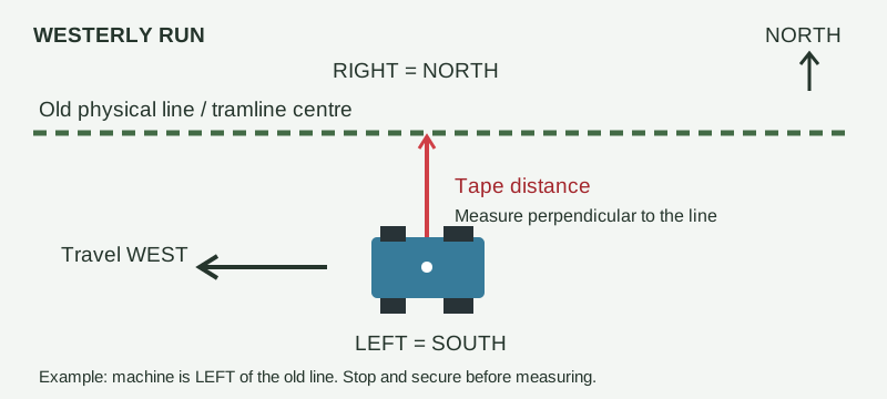
Write down: farm, field and line name; approximate heading; distance; left/right; correction mount and datum; time; and a photograph showing the tape and reference points.
2. Make a northerly run
Now find an old line running roughly north to south and do the same thing heading north. Leave the correction source and machine settings alone between checks. Stop, measure straight across from the old line to the machine centre, and write down the distance and left or right.
Facing north, left is west and right is east. These two checks help us work out how far the old data is shifted in each direction.
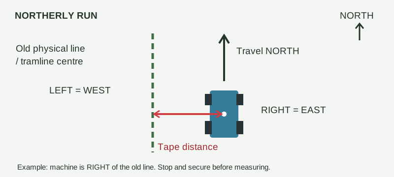
Repeat both checks at several unchanged locations. If several farms used the same old base, check each farm. Consistent measurements support one common shift; disagreement can indicate different line nudges, machine settings, rotations or other problems that a simple shift will not fix.
You do the measuring. We will handle the files.
Send us the two measurements, the line and paddock names, a couple of clear photos, and an original export from your screen. ISOXML is ideal, but if you do not know what your screen exports, just tell us its make and model and we will discuss what is possible.
You do not need to work out eastings, northings or file conversions yourself. We will look at the original data and your measurements, and check whether one sensible shift explains the problem.
If it does, we can prepare a separate corrected set of AB lines, boundaries, obstacles and keep-out areas, moved together rather than fixing every line by hand. Your originals stay untouched. If the measurements disagree, we will tell you: a simple shift is not the answer to every problem.
Allow 24-48 hours once we have your files and complete measurements. This gives us time to check the shift and discuss anything that does not add up. Where the data supports it, we can return corrected files in GDA94 and GDA2020 so you can use the version that matches your correction source. More complicated jobs may take longer; we will let you know.
If several farms used the same base, we need checks from each farm before treating them all the same. Once the corrected files are loaded, check them against several old tracks or unchanged reference points before putting them to work.
Start with the contact button below. We will arrange how to get your export and photos to us; logged-in customers can attach files to a support ticket. This helps align farm guidance data, not determine legal property boundaries. Where the reference itself is uncertain, you may need a surveyor.
Ask us about aligning my field data